Dr Steve Jones Senior Research Associate - Tyndall Centre for Climate Change Research
Analysing the spatial distribution of carbon dioxide in the ocean requires intensive calculations on all the measurements available. The data used in this comprised over 12 million measurements. This required several trillion calculations and a total computation time approaching 22 years. The ability to run dozens of jobs simultaneously reduced the actual time required to just seven weeks.
My work
The world's oceans absorb approximately 25% of the carbon dioxide (CO2) emissions produced by humans. This is significant portion of the global carbon cycle, and it is therefore critical that we understand how the oceans store CO2 and how this storage will change as more emissions are released in future.
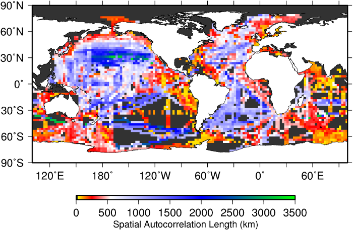
Much of this analysis relies knowing not only how much CO2 is in the ocean, but also how it is distributed through the different ocean regions. One important way to measure this is to calculate how carbon dioxide concentrations in the ocean water vary over different spatial scales. In some regions, particularly along ocean currents and in ocean gyres, CO2 concentrations can be similar across large regions as water from similar sources is spread over large distances. In other regions the concentrations are much more variable, such as through tides near the coasts or where water from the deep ocean is mixed with water at the surface.
The final result of these calculations is a map (below) that shows the distance over which two measurements can be similar in a given part of the ocean. In the North Pacific, you can travel 3,000 km and still find that the carbon dioxide concentration is similar to that found at your starting point. In other regions this can be less than 100 km. This information is valuable in many situations. For example, people operating future measurement projects can determine how closely together their measurements should be taken, and therefore how their resources can be utilised most effectively. It is also invaluable for certain types of climate models that can use the spatial variability of ocean CO2 concentrations combined with atmospheric CO2 data to assess how the atmospheric and oceanic carbon cycles interact.


)