
 |
||||||
Katabatic Winds |
 |
Katabatic flows are downslope density driven flows. They are ubiquitous over the polar continental ice sheets of Antarctica and Greenland, which means, as well as influencing regional weather, they play a role in the general circulation of the southern hemisphere. When katabatic flows reach the coast they can interaction with the coastal seas, or sea ice, and in certain locations opening polynyas and leads, and thus playing a role in the air-sea-ice processes and the generation of deep water masses. I am studying katabatic winds in Coats Land, Antarctica, with my former colleagues at BAS and others. Coats Land has fairly modest 2D topography which makes it representative of much of the more gentle fringes of Antarctica, and means the katabatic flows here tend to me 'ordinary' in strength, typically 7 m/s and with a katabatic flow depth of ~100 m. Our katabatic flow studies have encompassed a novel observing system and state-of-the-art numerical modelling. An annotated infra red satellite image of Coats Land, produced by Phil Anderson and myself is here.
|
|
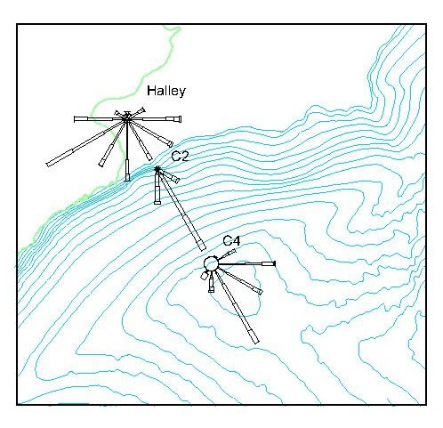
The bedrock of the observational programme has been a network of automatic weather stations (AWS) deployed in hourly recording mode from 1996 to 2003. Further details and data from the AWS network are here. The figure (above-right) shows the Coats Land topography (100 m contours) as background with wind roses from AWS data plotted on top. The wind roses are histograms of wind speed and wind direction (in bins of 5 m/s and 30 degrees), at Halley Research Station and two AWS sites (C2 and C4). These observations are conditionally sampled to have no solar radiation, be stable and have little synoptic-scale forcing - this picks out periods of katabatic flow, as evident at C2 and C4. Interestingly, there does not appear to be any katabatic flow signature at the surface at Halley. Taken from Renfrew and Anderson (2002).
|
|
|
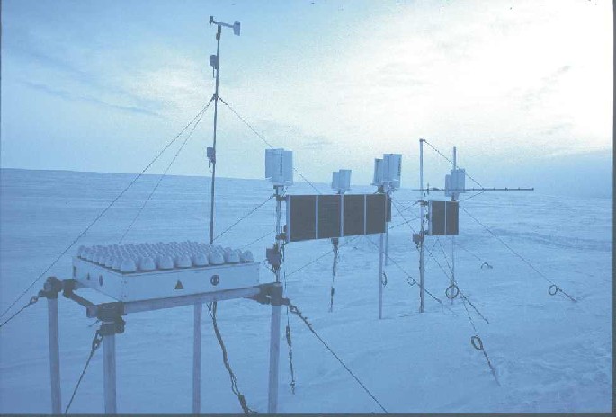
During 2002 and 2003 a novel autonomous Doppler sodar wind profiling system was operated in Coats Land. This system has provided the first wintertime continuous soundings of katabatic winds over Antarctica. The Doppler sodar system was designed and tested by BAS, as documented by Anderson, Ladkin and Renfrew (2005). Photos and details from its deployment in 2002 and redeployment in 2003 are here. Quicklook images of all the major observing periods are available here. Please contact me if you'd like the data. An analysis of the complete two year set of observations is published in Renfrew and Anderson (2006). Preliminary observations were used in the numerical modelling paper of Renfrew (2004). |
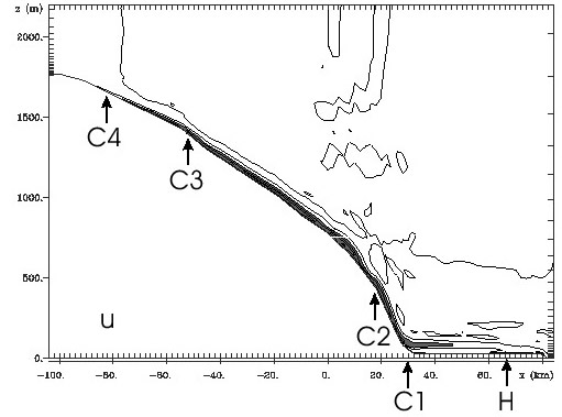
In tandem with the observational programme, I have been running a state-of-the-art numerical weather prediction model (RAMS see my links page). So far I have been running idealised simulations of katabatic flows over Coats Land. I have used the AWS and Doppler sodar observations to tune and validate the simulations, and have managed to produce fairly accurate idealised katabatic flow simulations, with some cavaets, as discussed in Renfrew (2004) & Renfrew and Anderson (2006). To the right is a cross-section of downslope velocity after 24 h of simulation time (from Renfrew 2004). Some more figures can be found here. In these non-hydrostatic simulations the model generated internal gravity waves at the foot of the continental slope as a result of the hydraulic (katabatic) jump that occurs there as the flow is dammed by the build up of a pool of cold air (Renfrew 2004). Katabatic jumps are explored further in Yu, Cai, King and Renfrew (2005). I have used the NWP experiments to address several interesting questions, for example: why katabatic flows don't generally cross the Brunt Ice Shelf and reach Halley (see above wind roses figure), and what is the force-balance of these flows. |
 |
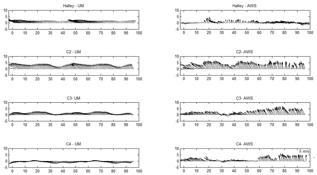
More recently Hanneke Luijting has been simulating several katabatic flow case studies from Coats Land, using the Met Office Unified Model (6.1). The UM does overall a reasonable job, as can be seen from this comparison (right) of simulated and AWS observed katabatic flow from summer of 2002. However there are some problems in simulating the very shallow structure of these katabatic flows, suggesting an inadequate representative of the shallow and stable boundary layers that are characteristic of these flows over Antarctica. More details can be found in Hanneke's PhD thesis, or in this extended abstract for the 18th AMS Boundary Layers & Turbulence Conference |
 |