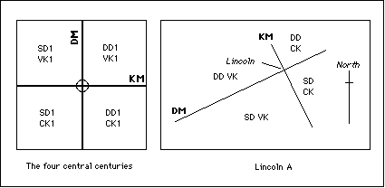
On the left is shown the numbering of the four central centuries. The surveyor is standing on this side of the Kardo Maximus looking towards the top of the diagram, along the Decumanus Maximus. On the right is a possible configuration for the Lincoln A cadastre based on the assumption that the origin was on the south wall of the Lincoln fort, and that the surveyor was looking in the direction of the greatest extent of the cadastre, towards Leicester (west south west).