

|
|
|||
|
|
|||
|
|
|||
|
|
|||
|
|
|||
|
|
|||
|
|
|||
|
|
|||
 |
|||
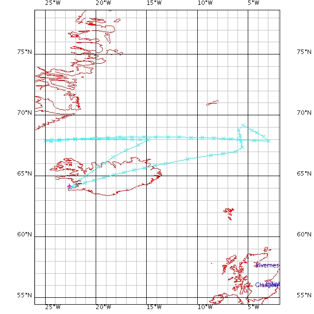
Sunday 25th February - Greenland Ahoy |
After a short delay as a result of frozen water and leaking pipes, the team of six departed from Keflavik. Heading north-east, the team was greeted by clear skies and beautiful views of snow covered Iceland. As we headed towards the cyclone and inside the Arctic Circle, bands of clouds could be seen in the distance and wind speeds increased. Clear skies moved in below as the aircraft flew over the eye of the storm, and sea waters could be seen from an altitude of 30kft. Ozone concentration peaked around the eye of the storm and winds weakened. Sixteen dropsondes were released in total, eleven in the 440nm straight level run due west towards Greenland. Anticipation grew we neared the coast of Greenland and the last dropsonde was released. The moment the pilot turned off the seatbelt sign, scientists and crew jumped from their seats, cameras in hand, waiting for the first glimpse of the mountainous coast. Spectacular views of the ice shelf, mountains and sea resulted in the pictures being taken from every window. The view included a stunning ice swirl in the waters just off the Greenland icesheet. |
||||
The stacked profile descent just off the coast brought the aircraft down to a height of 100ft. The low-level run began with calm seas and low winds, but as we headed east clouds moved in and the seas became rougher. Despite the turbulence, the whole team made it out with their lunches intact! The return flight home to Keflavik went smoothly as the team reminisced about their almost perfect flight. Maybe next time the pod of whales and the family of polar bears will greet us along the coast of Greenland! |
||||

