Since Roman cadastres may not totally reorganise a landscape, a local parcelling could be pre-Roman. However, if it is parallel to a Roman road, then it probably originated in the Roman period or later. This article studies two local parcellings within a British centuriation. It shows how different theories about the way in which the landscape changed may suggest different dates for that change.
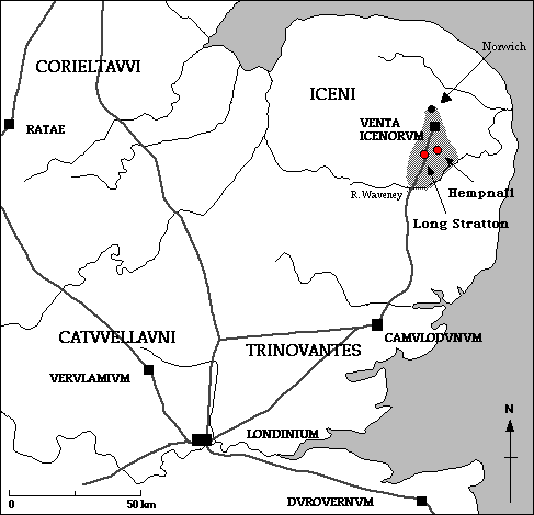
Aspects of the South Norfolk A cadastre (the grey area on the above map) are in print (Peterson 1988, 1993) and on the internet. A general description was published in an atlas of ancient cadastres, an output of COST action G2. The system is, in theory, a centuriation with module 709.5m and orientation 11.077 degrees west of north. Its grid coincides with 5 (or possibly 7) more or less certain "Roman roads". It is also crossed by main Roman roads which are oblique, of which the best preserved is that connecting Venta with Camulodunum.
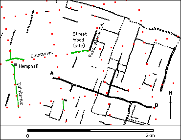
Peter Warner has studied this area and compared it to another regular field system (1) not far away. There are two salient aspects of his description and map (Warner, 1982: fig. 16):
 The figure presented here is based on accurate maps, which were those of the late nineteenth and early twentieth century at 6 inches to the mile (1:10,560), and mid-twentieth century at 1:25,000. The latter maps allowed the earlier cartography to be linked to coordinates of cadastral intersections calculated by computer. The figure does not support Warner's suggestion that the system south of Long Stratton is a centuriation. There is no major boundary parallel to road which is at 20 actus or a multiple. The part of the boundary to the west of the road which he claims to be at 20 actus is in fact at 18.95 ± 0.15 actus. This is too inaccurate to be used as evidence of a standard form of Roman land planning.
Despite this, we may still ask if some of these features could have been laid out in the Roman period. One indication of this would be the discovery of intervals between them corresponding to commonly used whole numbers of actus.
The results of this study in different areas are as follows:
Subdivision of 5 and 10 actus often play an important part in 20 actus centuriations, although other intervals have been seen. Thus major intervals of 15 and 30 actus could well be of Roman origin. Again, it has not been suggested that the smaller interval of 450 ft was a common measurement in England in the early medieval period. Accordingly, it is this area which seems most likely to have been re-surveyed during the Roman period.
Apart from the field boundaries, the other striking feature of this area is, as Warner says, the angular system of greens and commons. Five greens (of the eight shown here) have a common feature. A substantial portion of their boundary has the orientation of the local parcelling based on the main road, and another substantial portion has the orientation of South Norfolk 'A'. These greens appear to be essentially triangular, although truncated in two cases, the acute angle of the triangle being that between these two systems. Because of their awkward shape they would not be suitable for arable allotment, and left as common grazing. In the agrimensores' terms they are subseciua, and some of them may be genuine survivals of such features from the Roman period.
The shape of the greens seems to indicate the existence of two dominant orientations, and we may suppose that the orientation represented by the red features, the orientation of South Norfolk 'A', is earlier. This part of the main road appears to have been based on the cadastre. If so, and if the blue features are later than the road, then they represent a later orientation.
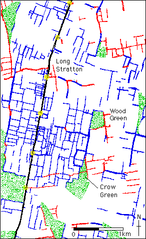
 Thus those red features that appear within the local parcelling may not be discordant features "overlaid" on earlier fields. Rather, they could be relict elements of the original layout. A case in point is shown at the right. At Long Stratton a road following a limes links the church (red circle) and hall (blue circle). It is discordant to the layout of fields aligned with the Roman road, seen in the bottom of the figure. The boundary at right angles, shown in red, bisects the century and is in fact a rectified water course. It may be compared to the oblique sections of another rectified water course to the west of, and crossing, Crow Green (see figure above). These traces indicate that, prior to the formation of the local parcelling, some reorganisation of drainage had taken place in the framework of South Norfolk 'A'.
Further evidence for the earlier layout is present around the margins of the Long Stratton local parcelling. It is possible to pick out seven segments of boundary at 10 actus from its limites, and we observe that the eastern boundary of Wood Green is at 800 ft from a limes (1/3 of a century), a distance which is of some interest, given the possible division of centuries into thirds within the cadastre further to the South.
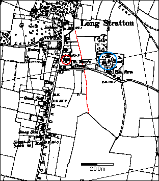
 Another feature of the local parcelling is that it appears to have been based upon some of the fixed points established by the implementation of the earlier grid. Six of the existing junction points on the east side of the main road are nearly coincident with the points of intersection of east-west limites of South Norfolk 'A' (highlighted). It looks here as if the process of reorganisation has deliberately and systematically preserved the pre-existing junction points, but only on the east side of the road. It could be argued that any systematic reorganisation is more likely to be Roman than Mediaeval. Hence the difference between the two areas (east and west of the road) would be consistent with the earlier suggestion, based on the metrology, that only the parcelling on the east side is likely to have been laid out in the Roman period.
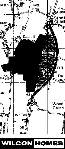
However there is some evidence that these junction points could have been reused at any time, even in the future! The figure on the left shows a proposal from a builder to construct a Long Stratton bypass (as part of a large housing development). Note that it was originally proposed to start and end it at the circled points, two of the points highlighted in the earlier figure.
Nevertheless there appear to have been two different ways in which the landscape south of Long Stratton was reorganised. To the east of the road the junction points were, in theory, probably systematically reused and new fields laid out using Roman measurements. To the west this systematic reorganisation does not seem to have happened. This implies different dates for the two reorganisations and suggests that, contrary to the views of Warner, the system is not a single "centuriation".
Several other features are identified by flashing red. They are the majority of the boundaries of this local parcelling and they have a similar relationship with the cadastre. They pass through termini at 600 feet. The observed system thus has the same sort of relationship to South Norfolk 'A' as that observed by Chouquer et al. (1987: 229) between two neighbouring Italian areas of land survey, Atella II and ager campanus II (although in that case the angular relationship is 3:2) .
It has not been suggested that Atella II is based upon a main road, but upon the pre-existing boundary stones of a neighbouring cadastre. However in this case it is possible that both these propositions are true. The question is which features in this area are really most likely to represent the course of a Roman road. The possibilities are:
A final observation on this figure is that, as at Long Stratton, there are traces which conform to the South Norfolk 'A' cadastre (the green lines show remnants of limites). Again these appear to have been left as relics within the local parcelling as the land was restructured to meet more local needs.
Thus we can draw rather different conclusions about the date of origin of the local parcellings examined here.
7 March 1997
Note 1
Warner's observations, which compare the Long Stratton area with that at Ilketshall in Suffolk just south of the Waveney, are as follows:
Note 2
Norfolk Sites and Monuments Record: County Number 10199
Roman road suggested by OS [Ordnance Survey].
R R Clarke found no evidence visible on ground 16 Oct1953, but noted name Street Wood, more extensive on Bryant's map 1826 and tithe maps than present wood shown on OS (now felled).
Note 3
A fuller explanation (Peterson 1992) provides a number of examples. The theory is also supported by work done independently on centuriations of the gulf of Corinth, where neighbouring grids are related at 1:4 (Romano & Tolba 1996).
Chouquer, G., Clavel-Lévêque, M., Favory, F., and Vallat, J. P. 1987. Structures agraires en Italie centro-méridionale. l'Ecole Francaise de Rome, Rome.
Clavel-Lévêque, M., ed. 1983. Cadastres et Espace Rural. Approches et réalités antiques (table ronde de Besançon mai 1980). CNRS, Paris.
Peterson, J. W. M. 1988. Roman cadastres in Britain: I - South Norfolk A. Dialogues d'histoire ancienne 14 : 167-199.
Peterson, J. W. M. 1992. Trigonometry in Roman cadastres. In Mathématiques dans l'Antiquité. Centre Jean-Palerne: Mémoires 11. edited by J.-Y. Guillaumin. pp. 185-203. Université de St-Etienne, St-Etienne.
Peterson, J. W. M. 1993. Computer-aided investigation of ancient cadastres. PhD Thesis. University of East Anglia.
Romano, D. G., and O. Tolba. 1996. Remote Sensing and GIS in the Study of Roman Centuriation in the Corinthia, Greece. In Interfacing the Past: Computer Applications and quantitative Methods in Archaeology CAA95. edited by H Kamermans and K. Fennema. Analecta Praehistorica Leidensia 28 II. pp. 457-463. University of Leiden, Leiden.
Warner, P. M. 1982. Blything Hundred: A Study in the Development of Settlement AD 400-1400. Ph D Thesis. University of Liecester.
Last updated on 13 August 2009 by John Peterson
(e-mail j.peterson@uea.ac.uk)
"A very similar regular field system to that at Ilketshall coincides likewise with a Roman road and is also bounded by a most unusual angular system of greens and commons. It too lies in a woodland area where medieval secondary settlement was established bordering the clayland commons.
What we see here are perhaps large areas of late Roman arable regression, a one-time abandoned landscape, partly reverted to common grazing and woodland, with the salient features, the Roman roads, the associated regular Roman field system, and the pre-Roman curvilinear estate boundaries all surviving, in outline, and being reused in the subsequent period of settlement expansion in the late Saxon and early mediaeval period." (Warner 1982: 53)References