THE PAST REVEALED
A bird's eye view of Caistor reveals the hidden secrets
of this once flourishing Roman town. What unlikely source gives us
the clue to that secret? The answer is under your feet.
In 1928, a pilot flying over Caistor noticed
a regular grid pattern of pale parched corn in the green barley fields
inside and around the Roman town.
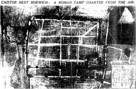
This photograph taken of Caistor Roman town in the
summer drought of 1928 was published by The Times in the spring
of the following year.
The pattern of dying corn formed over the lines of the buried Roman
gravel roads and stone walls. The soil is shallow in these areas and
holds less water, so the corn growing there ripens quickly and dies
while the surrounding corn stays green.
As more aerial photographs have been taken over the years, archaeologists
have used this valuable evidence to piece together plans of the buried
Roman town. Much of our understanding of the site has been gained
in this way.
When the aerial photograph was published in 1929, it caused a great
deal of local and national interest in the site. So much so that between
1929 and 1935 major archaeological excavations were carried out by
Professor Donald Atkinson. The evidence revealed by this work still
provides the main source of detailed information on the Roman town.
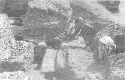
These photographs taken during the excavations show the large size of
the Roman buildings uncovered at the time.
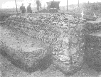
This view of Professor Atkinson's 1934 excavation was
taken close to where you are standing now. It shows the Roman town
wall curving in towards Caistor's southern entrance. The gateway is
13 feet wide with a guard room on either side. Originally it would
have had heavy wooden gates with a walkway and tower above.
The building shown here is the southernmost of the
two temples excavated in the centre of the town in 1929. It had a
square ground plan measuring 45 feet by 42 feet with walls up to 4
feet 6 inches thick. This building is the only one found at Caistor
in which carstone from north west Norfolk has been used.
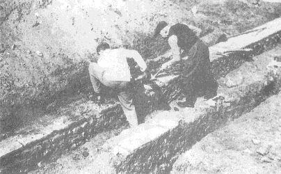
The two men in this photograph are cleaning earth from
the top of a low flint wall capped with red tiles. Both the walls
in the picture were built to form a solid foundation for large timber-framed houses.
After the excavation, the
buildings were re-buried to protect them from the weather, where they
still lie under a protective layer of soil and grass. In fact, the
remains of the south gate are still directly beneath your feet.


Last updated on 13 August 2009 by John Peterson
(e-mail j.peterson@uea.ac.uk)